


Maps
Artist / Author / Cartographer:
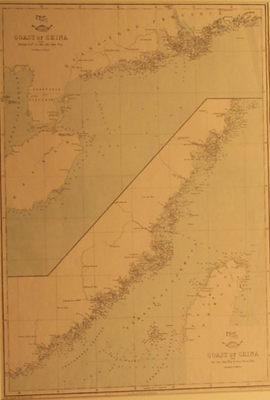
Weller, Edward
Title:
Coast of China (South)
Date:
c.1860
Medium:
lithograph
Size:
43 x 30 cms
Description:
Coast of China from Hainan Island to Hie-Che-Chin Bay, and from Hie-Che-Chin Bay to San Moon Bay. It shows the Northern part of Formosa and the coastline of Fukien and Quang-Tong with hydrographic soundings in fathoms. The English mapmaker Edward Weller engraved a number of maps of the China Coast in the second half of the nineteenth century. This map was published in the Weekly Dispatch Atlas in Fleet street, London and was lithographed by Day & Son, lithographers to Queen Victoria of England. I
References:
Item Code:
MA4692
attachment:
