


Maps
Artist / Author / Cartographer:
Title:
Date:
Medium:
Size:
Description:
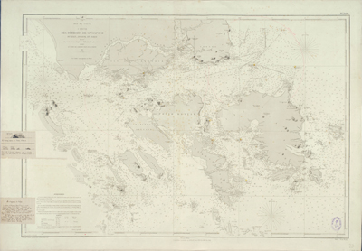
Carte Des Detroits De Singapour Durian, Jombol et Rhio Dressee d'apres les travaux Anglais et Hollandais les plus recents publiee au Depot des Cartes et Plans de la Marine, 1866.
Chart No. 2406. Les Sondes sont exprimees en metres. Gravee par Grenier, la teinte par Naudin; Nyon invr.. Ecrit par J. Burty. Corrections Essentielles en 1870. 1877. Juin 1880. Oct 1881. Dec. 1881.
The first edition of this French chart was published in 1866, utilizing French and Engish sources. This chart has corrections to 1881. Among other features, the map prominently notes the two lightouses erected under the direction of John Turnbull Thomson.
The chart is one of the earliest maps to focus in significant detail on the region, following only 20 years after John Turnbull Thomson and Samuel Congalton's original survey work in the region led to the publication of his monumental 2 sheet chart of the region in 1846.
Originally issued in 1866, the map is apparently drawn from a rare British Admiralty Chart entitled SINGAPORE STRAIT By Staff Commander JW Reed Navg Lieuts TH Tizard... Assisted by the Officers of HMS Rifleman 1865-69.
The chart extends to Johore, Battam, Bintang, Rempang, Galang, Jombol, Suji, Sanbon and neighboring islands, depcting coastal features, soundings, light houses, sailing directions and a host of other information.
A detailed French nautical chart of the coastal area around Singapore in the second half of the nineteenth century. The map has been used and bearings have been drawn on the map in red ink. Lighthouses are indicated in yellow and red. Singapore Island (Ile de Singapour) has quite a bit of detail. Bukit Timah (161) is highlighted in the middle of the island. Many places are named. The anchorage with soundings are shown. Additional manuscript notes are pasted on to the lower left of the map. They show perspective views and additional data to aid the navigator.
References:
Item Code:
attachment:
