


Artist / Author / Cartographer:
Title:
Date:
Medium:
Size:
Description:
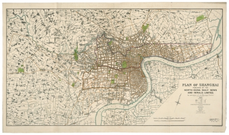
Plan of Shanghai published by the North-China Daily News and Herald Ltd. by Permission of the Municipal Council, 21st April 1928.
London: Stanford's Geographical Establishment, 1928
A magnificent large city plan of Shanghai published in 1928. The map covers a wide area and is depicted in fine detail and is based on the official plan of the Municipal Council of Shanghai with their permission. It was published by the North China Daily News and printed by the leading London map makers Stanford's Geographical Establishment.
The French and Shanghai International Settlements are marked by shaded borders, the area of each district given. A printed note reads "the Pootung shore is taken from surveys by the Whangpo Conservancy Board. The French Settlement is taken from surveys by the French Municipal Council". Street and building names are shown along the waterfront at the confluence of the Huangpu and Soochow Creek, but also into outlying rural areas. This map bears the printed signature of Charles Harper, the Commissioner of Public Works who had been with the department since 1902, oversaw an extensive phase of civic construction, and would be awarded the OBE in 1929 for his service with the Shanghai Defence Force.
Shanghai had since the 19th century, been divided up into the International Settlement, governed by Great Britain and the United States, whose enclaves were merged in 1863, and France. In 1927 the Nationalist Government drew up a plan to develop land in the north east of the city adjacent to the Huangpu River in an attempt to establish some form of Chinese authority by establishing the Special Municipality of Shanghai.
Framed.
References
The Library of Congress
References:
Item Code:
attachment:
