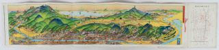
Pictorial Map of Major Sites and Transportation in Kyoto, East, West, South and North Kyoto.
Four folding coloured bird-eye view maps by Yoshida Hatsusaboro, each 17 x 74.5cm. Presented folded into beautiful coloured light card covers titled "The Kyoto Hotel" and measuring approximately 19 x 12cm. Tourist information printed in maroon ink on reverse of the maps. Light wear covers. Maps in excellent condition.
The famous bird-eye's view map artist, Yoshida Hatsusaburo (1884 - 1955), was commissioned to produce these four colour bird-eye's view maps of Kyoto by the Kyoto Educational Association to mark the Enthronement Ceremony of Showa Emperor in 1928. The four maps cover eastern, western, northern and southern Kyoto, each with detailed information on major sites on reverse. Yoshida was a renowned map artist during the first half of the 20th century with his characteristic compositions of bird-eye's view maps. His art became well-known when Hirohito as a young Crown Prince used Yoshida's pictorial map during his trip to Kyoto in 1914 and praised its effectiveness. As transportation became more accessible to the Japanese public, tourism thrived, and Yoshida's pictorial maps became very popular. His maps are beautifully drawn with accuracy and crowded with imaginative compositions. The coloured cover features a stage of Gagaku and a phoenix, symbolising the Imperial enthronement.
A beautiful example of the extraordinarily detailed handsome bird's-eye view maps by master pictorial map maker Yoshida Hatsusaboro.
Reference
Thank you to Sally Burdon and The Asia Bookroom for notes on these maps.