Maps

Artist / Author / Cartographer:
Bertius, Petrus
Title:
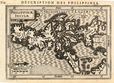
Philippines - Philippinae Insulae
Date:
1616(1618)
Medium:
copper engraving, later colour
Size:
9.5 x 13.5 cms.
Description:
One of the earliest published maps to feature the Philippines separately.
The fourth miniature map of the Philippines, after the maps by Barent Langenes 1598, Johannes Metellus 1601 and Cornelis Wytfliet 1605. The Bertius map also differs because of the wide borders with longitude and latitude shown.
The map was engraved by Jodocus Hondius Junior, the brother in law of Petrus Bertius.
References:
Thomas Suarez p.188 ; Geoffrey King p.82; Not in Quirino
Item Code:
MA3762
attachment:


