


Artist / Author / Cartographer:
Title:
Date:
Medium:
Size:
Description:
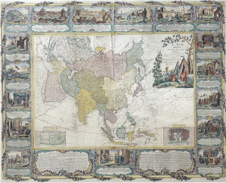
L' Asie Divisee en Tous ses Etats, dresse sur de Nouveaux Memoires, et Suivant les Derniers Observations.
A Paris. Chez Mondhare et Jean, Rue St. Jean de Beauvais pres celle des Noyers. Avec approbation et Privelege du Roy. 1788 Gravee par Chambon.
A magnificent baroque wall map engraved by Chambon,and published by Mondhare & Jean, in Paris, dates from the last years of the French Ancien Regime. It was compiled by the French geographers Longchamps and Janvier, and belongs to a sets of maps of the four continents. It Includes a wonderful rococo border with vignettes depicting the rise of the great historical empires of Asia. The extravagant cartouche pictures turbaned Turks on a tented encampment, while the insets at the bottom corners are town plans of Madras and Pondicherry, the major French settlement on the Coromandel Coast of India . The outline of the north-eastern limits of Asia is in the manner of a map of Asia by Homann Heirs published in 1754. The Sea of Korea (Mer de Coree) divides Korea and Japan. Hokkaido (Terre de D' Iesso) appears as a large island. The routes of various explorers are shown including, Antoine, Byron, Wallis and Bougainville. Also the route of the Manila galleon.
Gobert-Denis Chambon was a French engraver who worked in Paris in the second half of the eighteenth century. He worked with leading mapmakers including, S.G. Longchamps, J. Janvier and Cassini.
Some restoration although generally in good condition for a wall chart of this period.
Framed
References:
Item Code:
attachment:
