Artist / Author / Cartographer:
Title:
Date:
Medium:
Size:
Description:
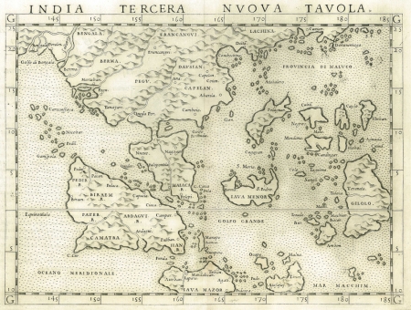
One of the earliest available maps of South East Asia printed in Italy in 1561. Malaca (Malacca) appears on the Malaysia peninsula. The islands of Camatra (Sumatra), Iava Mazor (Java), Iava Menor (Borneo) are shown. Also indicated are Polaguan (Palawan), Cubu (Cebu) and Negros which would soon become part of the Philippine Islands.
Also indicated beside Malacca is Cinca Pula or Singapore.
In 1548 the Italian mapmaker Giacomo Gastaldi added a fine map of South East Asia to his edition of Ptolemy's Geographia. Entitled, India Tercera Nuova Tabula, it was the third of his new atlas maps. It was based on a world map that Gastaldi had produced in 1546. In 1561 the map was re-engraved on copper at nearly twice the size for a new edition of Ptolemy by the Italian Girolamo Ruscelli working in Venice. It was republished several times up until 1599.
Framed with Optium acylic
References:
Item Code:
attachment:


