Artist / Author / Cartographer:
Title:
Date:
Medium:
Size:
Description:
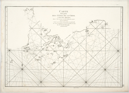
Pearl River Delta and Hong Kong - Carte d'une partie des Cotes de la Chine at des Isles adjacentes - Chart of part of the coast of China with adjacent Islands.
The chart of the Coast of China and the adjacent islands from Pedro Blanco to the Mizen was probably the earliest map based on scientific measurement of Hong Kong and the adjacent coastline. It was originally drawn by the Scottish hydrographer Alexander Dalrymple and was first published in 1771. This smaller version of the Dalrymple map was published by the French hydrographer Jean Baptiste d'Apres de Mannevillette for the Neptune Oriental c.1775. It showed the same soundings but also added rhumb lines.
It is regarded as a famous map of the Hong Kong area and a most important milestone chart based upon navigational surveys and soundings made in 1754, 1759, and 1760 by Alexander Dalrymple. This edition of Dalrymple's map was published by his friend and French colleague, Jean-Baptiste D'Apres de Mannevillette in his later editions of Neptune Orientale.
The chart extends from west of Macao and shows the Gueule de Tigre (Bocca Tigris or The Bogue) in the Pearl River to the North. The islands around present-day Hong Kong are depicted with Lantao and Lamma both identified. Hong Kong Island is shown as Fanchin Chow. An important map with latitude and longitude scales and rhumb lines, with soundings near coastlines and in bay areas.
Born in Le Havre of a seafaring family d’Apres de Mannevillette had a long and distinguished career as a navigator and one of the first French hydrographers. After studying mathematics in Paris, he gained early experience of the sea in a voyage at the age of nineteen to the Caribbean. During many subsequent voyages he assembled a collection of material for a projected hydrographic atlas which, with the support of the Academie des Sciences, was published in Paris in 1745 under the title Le Neptune Oriental. In spite of the popularity of the first issue, it failed to satisfy the author and he spent nearly thirty years, often with the assistance of his friend, Alexander Dalrymple, the English hydrographer, in the preparation of a revised and enlarged edition which eventually was issued in 1775. Alexander Dalrymple was a hydrographer who worked for the East India Company from 1752 - 1771. He became first hydrographer to the East India Company in 1779. He was appointed director of the newly founded Hydrographical Office in 1795.
The Manevillette chart is quite scarce.
References:
Item Code:
attachment:


