


Artist / Author / Cartographer:
Title:
Date:
Medium:
Size:
Description:
ex MOA2021
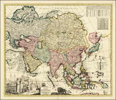
Asiae in Tabula Geographica Delineatio admentem Novissorum eorumque optimorum Geographorum emendata Indicibus Utilissimis . . . .
Scarce of map of Asia, published in Amsterdam.
The map bears the additional names of Peter Schenk and Nicholas Visscher.
The northeast coastline is shown with Witsen's information on Siberia. Hokkaido and Honshu (Terra Yedso) are joined together by a narrow isthmus and separated from the mainland by a wide straight.
An accompanying note acknowledges Scherer as the source, although the orientation of Yedso and Companies Land appears to be based on the De L'Isle model.
A huge lake appears in Tibet -- the legendary Lake Chiamay. A second lake is shown in the position usually occupied by Lake Chiamay, but here it is named L. Cananor Cimabete.
In Southeast Asia the straits between New Guinea and Australia appear in a tentative fashion, noting Dampier's Strait and a disembodied Carpenteria with no definite northern limit.
The map is decorated with a large, uncolored cartouche featuring Arab merchants, a fort, a pair of leopards and a fierce lion.
Adam Friedrich Zürner (1679 – 1742) was a German Protestant priest and cartographer.
Zurner's first project of note was a map of Saxony, for which he was retained by August III, King of Poland, in 1711.
Zurner was appointed Geographer of Poland and the Electorate of Saxony, a position in which he served until 1732. During this time, he reportedly traveled nearly 18,000 miles and created over 900 maps.
In 1721, he was tasked with establishing a postal road system in Saxony and marking the distances with stone posts.
Despite his prolific work product, none of Zurner's original manuscript maps appear to have survived.
References:
Item Code:
attachment:
