Artist / Author / Cartographer:
Title:
Date:
Medium:
Size:
Description:
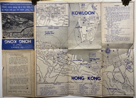
The Seafarer's "Chart" of Hong Kong: A tourist map of Hong Kong This "chart" greets you with best wishes for a happy stay in this British Crown Colony.
by PORT WELFARE COMMITTEE.
A plan of Hong Kong produced by the Port Welfare Committee, an organisation set up to support seafarers in the city. On the map dotted blue lines mark the paths of the ferries between the Kowloon and Hong Kong sides of the city, and the map key numbers and letters and place names are printed in blue as well. A blue square on the Hong Kong side outlines the area covered by the inset map at the top left hand corner. To the right of the plan is a note, Causeway Bay Reclamation, which is referring to the land reclaimed for Victoria Park which was completed in 1952. There is a photograph of the port, showing Chater Hall (completed 1955) lower centre, on the upper cover above an introduction entitled, A word about Hong Kong, by Allister Summerfelt, Chairman, Port Welfare Committee.
On the back is a guide containing information on places of worship, public services and entertainment, with photographs of four important buildings for mariners in each corner. in A note at the bottom of the page states, The publishers gratefully acknowledge the loan of map blocks compiled by Servicemen's Guides.
This is the earliest of this type of plan that we have come across. It is undated but was probably published in 1955.
References:
Item Code:
attachment:


