


Artist / Author / Cartographer:
Title:
Date:
Medium:
Size:
Description:
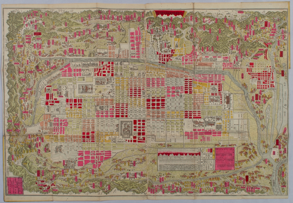
[Kyōto ku-kumi meisai-zu]. Map of Kyoto with Districts in Details
by Kamisaka Yoshishige. Edited by Tanaka Jihei]. Kyoto. Meiji 23 [1890]
Detailed hand coloured copperplate map of Kyoto, in original covers, paper title label upper cover. Covers a little marked with small sections of abrasion to lower covers. A very attractive map in very good condition. 49 x 71cm.
This fascinating map of Kyoto city and the surrounding region describes in detail the city. Street names and surrounding areas extending to Uji in the south and to Kurama in the north are shown together with major attractions, such as temples and shrines, which are delicately drawn and labelled.
In 1868, during the Meiji Restoration, the city of Kyoto was organised into 45 sections: kumi, administrative units; in Kamigyō [Upper Capital] district and 41 sections in Shimogyō [Lower Capital] district based on the earlier town system. The next year, however, these sections were reorganised into 33 sections in Kamigyō and 32 sections in Shimogyō to further modernise the town system. Each section was designated as a primary school district and these districts are shown in differing colours. School addresses appear on the left side of the legend.
The right side of the legend section shows distances of various places from Sanjō Bridge, which is regarded as the centre of the old capital. Although Kyoto has expanded and changed over the last 130 years, the town blocks and streets remain the same.
A beautiful city plan of the ancient capital of Kyoto printed in the late 19th century.
References:
Item Code:
attachment:
