


Artist / Author / Cartographer:
Hong Kong Publisher
Title:
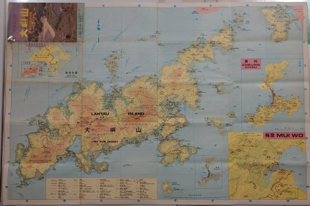
Map of Lantau Island
Date:
1984
Medium:
coloured print
Size:
58 x 88 cm
Description:
A detailed map of Lantau Island with three inset maps of Hong Kong, Cheung Chau and Mui Wo. At the bottom of the map there is an index showing footpaths, roads, contours, treams or watercourses, country park boundaries, Lantau Trail, ferry routes and many other features.
On the east side Tai Pak Wan (Discovery Bay) is shown. On land it is entitled, Discovery Bay Holiday Super Residential Area. Discovery Bay is a resort town on Lantau Island which started being developed in the late 1970s and early 1980s. At the time of this map it was in its infancy.
On the reverse of the map are popular tourist destinations on the island along with ferry and bus timetables.
References:
Item Code:
MA8290
attachment:
