


Artist / Author / Cartographer:
Title:
Date:
Medium:
Size:
Description:
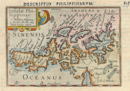
The first seperate map of the Philippines was engraved by Petrus Kaerius (Peter van den Keere) in Amsterdam at the end of the sixteenth century. It was based on Jan Huygen Van Linschoten's map of the East Indies of 1595.
The first seperate map of the Philippines was engraved by Petrus Kaerius (Peter van den Keere) in Amsterdam at the end of the sixteenth century. It was based on Jan Huygen Van Linschoten's map of the East Indies of 1595. The Dutch cartographer and engraver, Pieter van den Keere, produced a number of maps together with his brother-in-law Jodocus Hondius. Page 615 from Barent Langenes book "Caert Thresoor ". Latin text verso page 616
The Dutch cartographer and engraver, Pieter van den Keere, produced a number of maps together with his brother-in-law Jodocus Hondius.
References: King, Geoffrey, L. Miniature Antique Maps, Second Edition 2003
References:
Item Code:
attachment:
