


Artist / Author / Cartographer:
Title:
Date:
Medium:
Size:
Description:
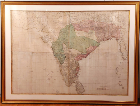
The East Indies, with the Roads. By Thomas Jefferys, Geographer to the King. MDCCLXVIII. The Second Edition. To the Directors of the Honble East India Company, Thos. Jefferys humbly dedicates this map.
A magnificent wall chart of India. One of the largest English language maps of India of the period, with beautiful original colour.
Jefferys' map of India was the most detailed to date, and of great practical importance during a period of the Honourable East India Company's expansion in the area. Depsite the detail, there are large parts of central India which are 'little known and in a manner independent.'
Sayer's map is a fine combination of known information and blank areas where little or nothing is known. The map is dedicated to the Directors of the East India Company.
References:
Item Code:
attachment:
